Ecology: Entering the Drone Age
To Plot, or To Fly?
For surveys of vegetation and habitats, plot-based measures yield a tremendous level of detail, revealing the species present, their relative quantities, aspects relating to stature, and also provide an opportunity to collect important covariate data such as landform details.
However, not in all instances is this level of detailed data required to meet the research objectives. Alternative methods of collecting less detailed data can allow the collection of a greater extent of data collection. Unmanned aerial vehicles (UAV) provide new opportunities to gather data at scales and levels of precision previously unattainable to fieldworkers engaging in traditional plot-based studies.
Within a matter of minutes, a UAV can cover an extensive area of a given ecosystem, collecting high-resolution, geo-registered images, which can easily be stitched to form a highly-informative orthomosaic. Accuracy of such imagery can be further increased with the use of ground control points, reducing the horizontal and vertical error in the resulting imagery. The flight path can be saved, to allow precise (GPS directed) remeasure of the same area on a subsequent day, season or year. This technology opens up new opportunities for mapping vegetation communities and ecosystem changes across time.

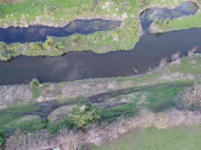
Seasonal raupo die-back along with carex sedge and floating-aquatic plant growth in a wetland ecosystem.
The ability to collect high resolution video in previously inaccessible places provides new opportunities to raise awareness of natural areas–bringing natural areas into reach of many via social media.
Visit an ancient forest canopy:
Fly across rivers and wetlands:
Gain new perspectives in a somewhat familiar environment:
Using a collection of a number of geo-registered photographs, photogrammetric techniques provide a means of representing a given feature in three dimensions, and allowing for horizontal, vertical and volume measurements of the surfaces photographed. This presents new opportunities for ecological surveys and monitoring, particularly of temporal changes in vegetation structure and condition.
Multispectral scanning provides an opportunity to detect patterns in vegetation vitality not visible to the naked eye. Scanning the reflectance of vegetation in the infrared and near-infrared bands provides insights into photosynthetic activity of vegetation and the degree of stress vegetation is experiencing. Reflectance results can be interpreted using established indices such as the Normalised Difference Vegetation Index (NDVI). Forbes Ecology proposes to utilise this technology, using a Parrot Sequoia multispectral sensor, on gradients of native forest structure (treeland to patch stand densities) subjected to seasonal water stress with an aim to identify previously invisible drivers of forest loss in New Zealand dryland environments.
Forbes Ecology owns a state-of-the-art UAV platform, including multispectral remote sensing capabilities, and is highly motivated to advance the use of these technologies for the conservation and sustainable management of ecosystems.
Please contact Dr. Adam Forbes with any questions and for further details to utilise this technology on your project.
Dr. Adam Forbes
Principal Ecologist
Mobile: 022 3672326
Email: adam@forbesecology.co.nz
Biodiverse, is the Forbes Ecology Blog. You are able to follow this blog by entering your email address here. You can unsubscribe at any time.